Can you feel it beginning? The original great migration referred to the movement of Black Americans out of the rural south between 1916 and 1970 into the cities of the North, Midwest, and West [1] But today, it is time to discuss the next great migration as changes in our climate and sea level turn parts of our coastline into uninhabitable wetlands. It is time to talk about climate migration.
Let’s get the “elephant in the room” out of the way upfront. This is not about the underlying cause of climate change which remains a divisive issue. This is about our rising sea levels and the increasing strength of storms, something we have observed, and this is actually a part of our altering climate.
Prior to inundation, habitable uplands above the high tide line first convert to uninhabitable wetlands, forcing human exodus. Habitability, not the land's presence above the low tide line, drives exodus.
That is from the opening paragraph of a study of the last offshore fishing community in the Chesapeake Bay. The Chesapeake is a “drowned river valley,” a product of our last Ice Age. It is relatively shallow with an average depth of 20 feet and is technically an estuary. I, too, had to look at that definition. An estuary is a partially enclosed coastal water receiving water from both the sea and rivers. (The Hudson River is also an estuary, who knew?). Tangier was settled in the 1770s as a farming community, but as the water surrounding the island encroached upon the land, the soil was no longer suitable for farming. Tangier has been an active fishing community since the 1800s, with a current population of about 500.
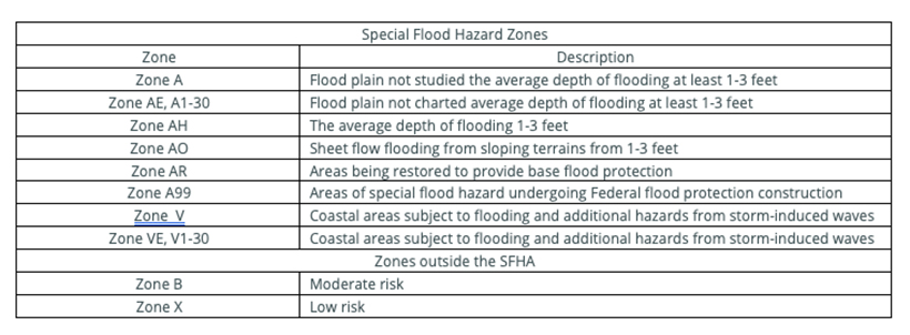
Topographically the island has three ridges but is essentially flat. The highest point is 1.5 meters above the mean higher high water – the average highest high tide recorded. The Federal Emergency Management Agency (FEMA) has established zones of potential flooding [2]. Special Flood Hazard Areas are likely to flood once every 100 years or, as they state, within the time of a 30-year mortgage. The highest areas of Tangier have a moderate risk of flooding every 500 years, but the larger portions of the Island are classified as zone AE – they will flood, and flood insurance and a flood management plan are mandatory.
As the sea level rises, more and more land become wetlands – permanently or seasonally flooded areas. You can, for a while, build upwards, but in the end, the area is uninhabitable. Tangier has lost two-thirds of its habitable land since 1850 due to rising sea levels and coastal erosion. The current “uplands” are set back from the coast, so any loss here is usually attributable to a rising sea level. Using a variety of aerial images dating back to 1967, the researchers determined that Tangier has lost an additional 56-71% of its remaining “high ground.
"The majority of individual properties in the Town now hold some wetlands. Some properties have been converted almost entirely to wetlands, in such cases the home and any support structures (storage sheds, walkways, parking platforms) on the property have been raised."
The researchers predict that with the increasing loss to wetlands, Tangier will be unoccupied by 2053, irrespective of any coastal erosion mitigation or further raising of structures. As they point out, once the community’s infrastructure, e.g., schools, grocery stores, and roads, become too difficult to maintain or protect, movement off the island will accelerate. To continue as a viable home, there are many social issues particular to the Island and small rural communities that we need not consider for the moment.
We could relocate those 400 souls, their homes, and belongings, but it is estimated the cost would be $100-200 million. We could also protect Tangier by placing protections around most of its shores and raising the three habitable ridges by 3 meters. The researchers estimate the cost at $250-300 million. They end on this note.
“If the Town and Island of Tangier are saved via human intervention or abandoned to rising waters and its people relocated to the mainland … it is a choice that will soon need to be made by policymakers. The choices they make will soon define how our fellow Americans in the USA most vulnerable to climate change, which are often Native American, minority, or low-income such as the isolated fishing community of Tangier, will have their needs addressed—or ignored. The same holds true for many coastal communities throughout the world.”
Before we consider those global coastal communities, let us turn our attention to another area in the US facing rising sea levels and coastal erosion – The Hamptons.
Raise or Raze
The Hamptons’ problems differ from that of Tangier; they face coastal erosion and a rising sea level. As it turns out, the Hamptons was the site of the first attempts at mitigation and is currently the largest demonstration project of climate mitigation by the Army Corp of Engineers. In 1938, the “Great New England Hurricane” broke through the barrier islands and flooded the home of Juan Trippe – founder and chairman of Pan American Airways. He asked that jetties running perpendicular to the shore be installed to protect his home from the ocean.
While the land lost would have to be “renourished” with sands, those jetties would reduce the wave action that eroded the beach by moving sand from the east to the west. These two actions, renourishment, and alterations of the seascape’s built environment, remain the primary weapons in the Army Corps of Engineers’ arsenal. Of course, no good deed goes unpunished, and the beach and homes to the west of the jetties lose more and more sand than before.
“The western end in that era was home to the summer cottages of cops, firefighters, and other civil servants fleeing the heat of the city. The eastern end was home to the richer estates, including Trippe’s, and those owners didn’t want to wait for their jetties.”
Unlimited Sand and Money Still Won’t Save the Hamptons
That, of course, reveals another issue when we speak of climate migration, how do we equitably deploy funds. The Army Corps follows guidelines that seek to boost economic development and protect the environment. They must do a cost-benefit analysis for every project. As a spokesman stated, “It may sound hardhearted, but to be fiscally responsible and to be stewards of taxpayer money, we have to abide by the greater benefit of the public good.” For the Hamptons, every dollar spent saves $2.20 in anticipated losses. It takes only a moment to realize that the benefit may be skewed with an average sale price for a home at $2 million. But once again, I digress
Between 1960 and the 70s, 15 more jetties were built, all increasing erosion to the west. Local governments, responsive to the rising tide of complaints of their western constituents, stopped their funding, eastern constituents went to court. Storms in 1992 and 1993 broke through barrier islands and washed-out Dune Road in Westhampton. Dozens of homeowners had no home or land, 78% of homes in the newly created township faced loss. They banded together, formed the town of West Hampton Dunes to gain access to property tax money. The federal, state and local governments agreed to restore and maintain their beaches. The Army Corps is obligated to provide fresh sand and maintain the beaches until well into the 2050s.
“The current federal plan calls for bolstering communities including Montauk, Southampton, and Fire Island, where the average home values are $1.7 million, $2.8 million, and $1 million respectively. In Mastic Beach, a seaside area between Fire Island and Southampton where prices average $310,000, federal funds will be spent to acquire and destroy 14 flood-prone houses.”
There are three choices. Homes can be raised and designed so that water flows through rather than into them. The experience with that effort in New York after Sandy was expensive and corrupt, and homeowners had to find other places to live while the work went on. We have yet to test the result against nature. We can ask or require homeowners to move, as will happen in Tangier. According to the Army Corps' studies, for the Hamptons, that would be “generally cost-prohibitive due to high property values.” Renourishment with sand [3] will cost an initial $500 million covered by the federal government, with continued renourishment shared with local governments. It is anticipated that maintaining 80 miles of Long Island’s southern barrier islands and coastal areas will cost $1.5 billion in the next 30 years.
- Over more than a century, Long Island’s wetlands shielded by barrier islands have eroded by about 20 inches per year
- The sea level on Long Island is rising by about an inch a year
- If you look at a map of the current flood plans, this area on Long Island is not the problem; it is the coastal areas of New York City that are far more densely populated.
“You can continue to pour sand and build beaches if your money is infinite and your sand is infinite. Of course, - neither of those is true.”
Alison Branco, coastal director for the Nature Conservancy in New York.
[1] For a beautiful historical description, consider The Warmth of Other Suns by Isabelle Wilkerson
[2] Flooding is the most common and expensive of our natural disasters. Losses are covered by the federal government’s National Flood Insurance Program. It requires those in flood zones to have floodplain management programs, to buy insurance if they carry a mortgage on their homes, and provides grants to buy out or rebuild. “Repetitive-loss properties” that flood over and over represent 2% of insured properties and 40% of losses. Here are the zones.
[3] With 8% of federal sand renourishment, New York is fifth behind California, Florida, New Jersey, and North Carolina.
Sources: Predictions of the Climate Change-Driven Exodus of the Town of Tangier, the Last Offshore Island Fishing Community in Virginia's Chesapeake Bay Frontiers in Climate DOI: 10.3389/fclim.2021.779774
Unlimited Sand and Money Still Won’t Save the Hamptons Bloomberg Green
A series of articles in the New York Times dating back to 1999 can be found, here, here, here, and here.

Chuck Dinerstein, MD, MBA
Director of Medicine
Dr. Charles Dinerstein, M.D., MBA, FACS is Director of Medicine at the American Council on Science and Health. He has over 25 years of experience as a vascular surgeon.